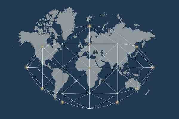
The 12 Vile Vortices describe a global pattern of strange phenomena. Ivan T. Sanderson coined the term and mapped these sites into a vortex energy map that corresponded to the ancient idea of ley lines.
This article focuses on the geographic, historical, and structural patterns behind the 12 Vile Vortices. It explains the anomaly-based side of the Earth energy grid. These locations correspond to reports of navigation problems. There’s magnetic drift, strange weather, and other unusual events worldwide. Thus, the term, vortex energy map.
For the metaphysical and experiential view of dark and light energy in ley lines, see the article on Dark Energy and Light Energy.
For the architectural and cultural expression of this same grid, see the companion article on 38 Ancient Sacred Sites.
Here we will look at the original model and the geographic pattern behind it. We will also see how later maps turned these locations into “energy points” and why the idea continued to grow.
The goal is to explain the twelve vortices and how later energy-point maps developed from them. This shows how the systems connect without mixing them or rewriting their history.
What are the 12 vile vortices?
Researcher Ivan T. Sanderson identified the 12 vile vortices. The sites formed what he saw as a repeating global pattern of strange events. The basic idea was simple: some places on Earth seemed to behave in ways that did not match the areas around them.
The model placed five vile vortices along the Tropic of Cancer, five along the Tropic of Capricorn, and two at the poles. This layout became the base for later ideas about energy points and the map that grew from it.
The name “vile vortices” reflected the strange reports connected with these places. Ships drifted off course. Compasses spun. The weather shifted without warning. Stories repeated across cultures. These patterns were seen as possible signs of a deeper structure shaping the planet.
Origins of the concept
The idea began with strange reports collected from around the world. Many seemed to line up in repeating bands across the planet. The reports included missing ships, drifting compasses, and sudden changes in weather.
These patterns were viewed as more than random events. The theory proposed that Earth had natural zones where physical forces behaved in unusual ways. Mapping the reports produced twelve clusters.
The model grouped the vortices along the Tropic of Cancer, the Tropic of Capricorn, and the two poles. This created a repeating geographic arrangement across the globe.
If the same reports repeat across continents, what underlying pattern are they pointing to?
How Sanderson described each vortex
Each location was treated as a mix of place, pattern, and physical effect. The geographic setting came first, followed by the type of anomalies reported there. These included drifting compasses. They also faced sudden storms and strange currents. There were tales of lost travelers too. Repeating signs helped determine whether a location belonged on the map.
The model also included an interpretation of those reports. Natural zones where magnetic and atmospheric forces behaved in unusual ways were thought to exist around the Earth. Similar signs appearing in different parts of the world were treated as possible evidence of a larger pattern.
Modern views are mixed. Some researchers seek scientific reasons for the reports. Others wonder if the patterns are even real. The method remains clear, even with the debate. Locations were mapped by the stories tied to them and the physical effects reported by people.
Are these repeating signs a coincidence or the signature of a deeper planetary system?
The geographic pattern behind the vortex energy map
The 12 vile vortices were not treated as unrelated locations. The reports formed a repeating global arrangement. Five locations showed up in the northern band, five in the southern band, and two filled the pattern at the poles.
The original model examined where unusual reports were clustered. It also studied navigation, magnetic, weather, and environmental issues around the world.
Later researchers built on this idea. They created more complex planetary grid systems. These systems used geometric overlays and added more locations. Those later developments fit into the expanded Earth grid, not the original anomaly model.
➡ For More See: 38 Ancient Sacred Sites on the Earth Grid Ley Lines Map.
Do these repeating locations reveal a real global pattern, or are unrelated anomalies being connected after the fact?
The 12 vile vortices (Sanderson’s original list)
Northern hemisphere vortices (Tropic of Cancer)
The original vortex energy map was built from reports that repeated across time and place. The sites were grouped by latitude because the patterns lined up along the same global bands. The northern group sits on the Tropic of Cancer and shows the strongest mix of navigation errors and strange weather.
Why do so many unrelated regions along this latitude echo the same strange behaviors?
1. Bermuda Triangle
The Bermuda Triangle is the most well-known of the 12 Vile Vortices. It became a clear example of reports involving ships and planes drifting off course without warning. The mix of magnetic shifts and sudden storms was cited as one reason this site stood out.
2. Algerian Megalithic Ruins
This site sits in the Sahara Desert near ancient stone structures. Reports included unusual heat patterns, strange mirages, and compass drift. Its location also showed that the proposed vortices were not limited to oceans or coastlines.
3. Indus Valley Region
The Indus Valley covers parts of Pakistan and India. The region was linked to sudden weather changes and magnetic irregularities. It is also significant for stories of lost travelers. It helped support the idea that the 12 vile vortices formed a repeating pattern across continents.
4. Hamakulia, Hawaii
Hamakulia is a volcanic zone on the Big Island of Hawaii. Magnetic swings, deep-sea vents, and sudden ocean changes were linked to the idea of a vortex there. The site later became important in discussions about energy points because of its strong natural forces.
5. Devil’s Sea (Dragon’s Triangle)
The Devil’s Sea sits off the coast of Japan and mirrors the Bermuda Triangle in many ways. Reports of drifting ships, strange fog, and missing vessels made it another major point on the map. Its position across the Pacific also added to the idea of a repeating global pattern.
Southern hemisphere vortices (Tropic of Capricorn)
The southern group sits along the Tropic of Capricorn. These sites showed the same mix of strange weather, magnetic drift, and repeating reports found in the northern group. Together, they helped form the full pattern of the map.
What makes the southern band mirror the north so precisely in its anomalies?
6. South Atlantic Anomaly Region
The South Atlantic Anomaly sits off the coast of Brazil. Satellites and navigation tools faced issues in the area. This was one of the unusual effects linked to it. This made it an important example because the reported effects reached both sea and sky..
7. Zimbabwe Megalithic Ruins
This area in southern Africa is known for ancient stone structures. Reports included unusual magnetic readings and sudden weather shifts. These patterns were seen as similar to the other sites in the global grid.
8. Wharton Basin
The Wharton Basin lies deep in the Indian Ocean. Reports of drifting ships, odd currents, and seismic activity helped place it among the 12 vile vortices. Its remote location made many of the stories harder to confirm, but it fit the proposed pattern.
9. New Hebrides Trench
This site lies in the southwest Pacific near a deep ocean trench. Reports included sudden storms, shifting winds, and navigation errors. The mix of deep-sea forces and surface weather made it another proposed vortex site.
10. Easter Island
Easter Island is famous for its ancient statues. However, the vortex model identified magnetic irregularities and unusual weather patterns. It became a key point in the southern band.
Polar vortices
The final two sites were placed at the poles. The North Pole and South Pole were believed to show the same repeating signs found in the other zones. These locations completed the proposed global pattern.
If the poles complete the pattern, what does that say about the forces shaping the entire globe?
11. North Pole
The North Pole fit the model because of its shifting magnetic field and extreme weather. Drifting compasses and sudden whiteouts were reported. These effects matched those seen at other sites on the map.
12. South Pole
The South Pole showed similar signs. It should be included because of strong magnetic distortion. Unusual atmospheric effects and navigation problems are also reasons. Together, the two poles completed the global layout of the 12 vile vortices.
The vortex energy points map
The twelve anomaly zones later became a starting point for broader Earth-grid maps. These later systems kept the idea of globally connected locations but expanded both the map and the meaning attached to it.
One development added geometric grids, ancient monuments, temples, pyramids, and other sacred sites. Some interpreted these locations as energy points. Here, the Earth’s energy gathers, shifts, or becomes easier to feel.
These later systems grew from ideas connected with the original vortex map, but they should not be treated as part of the original model.
➡ For More See: 38 Ancient Sacred Sites on the Earth Grid Ley Lines Map.
➡ For More See: Dark Energy and Light Energy Ley Lines Earth Grid Network.
How did an anomaly map become the foundation for several different Earth-grid systems?
Scientific and skeptical interpretations
The 12 vile vortices sit between reported anomaly and interpretation. The original theory treated the reports as a meaningful global pattern, but that idea remains debated.
Skeptical explanations focus on the individual events. Storms and ocean currents can cause unusual experiences. Magnetic changes and navigation problems do too. These things happen naturally. No hidden planetary system is needed.
Do the twelve locations create a meaningful pattern when looked at together? Supporters believe they do. Skeptics doubt if the reports are strong and consistent enough to back that conclusion.
This article does not need to decide whether later metaphysical interpretations are correct. These interpretations connect to the companion article on dark energy, light energy, and ley lines.
➡ For More See: Dark Energy and Light Energy Ley Lines Earth Grid Network.
Do these twelve locations reveal a real geographic pattern, or are separate events being grouped into one?
Conclusion
The 12 vile vortices started from efforts to map frequent reports of navigation issues. These included strange weather, magnetic effects, disappearances, and other odd events. Ivan T. Sanderson thought the twelve locations created a repeating global pattern. He didn’t see them as random events.
That original anomaly model is the focus of this article. Later, researchers broadened the map into bigger geometric systems. They also linked it to ancient sacred sites. Some views see these places as energy points. They have special metaphysical or experiential meaning.
Those later developments belong to the companion articles.
➡ For More See: 38 Ancient Sacred Sites on the Earth Grid Ley Lines Map.
➡ For More See: Dark Energy and Light Energy Ley Lines Earth Grid Network.
References
- Invisible Residents: The Reality of Underwater UFOs. Ivan T. Sanderson, 1972.
- Earth’s Magnetic Field. NASA Earth Observatory.
- South Atlantic Anomaly. NOAA Space Weather Prediction Center.
- Geomagnetism FAQ. NOAA National Centers for Environmental Information.
- Bermuda Triangle. Encyclopaedia Britannica.
- The Devil’s Sea Mystery. Skeptical Inquirer.
- What Causes Earth’s Magnetic Field? U.S. Geological Survey.
- Why Is the Earth’s Magnetic Field Weakening? Scientific American.
About this project
The Seeker Project 4 Spiritual Exploration (SP4SE) is a project of Americans In Alliance. The mission of SP4SE is spiritual education. The mission of Americans In Alliance is environmental conservancy. Click the links below to learn more and support our efforts.