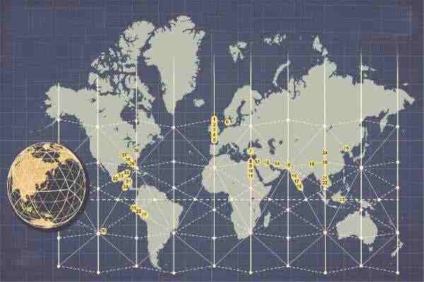
The 38 famous architectural sites on the global ley lines grid map are not a coincidence. They belong to a global energy network called the Becker-Hagens planetary grid map. Some of these archaeological treasures are likely on your travel wish list.
Global networks are not an invention of the modern world. Ancient civilizations designed and built them eons before recorded history. It prompts several questions.
Exploring Famous Architectural Wonders
What are ley lines, and what do they have to do with ancient sites? Researchers believe ley lines act as hidden routes for magnetic or electrical energy. They connect ancient landmarks, sacred sites, and natural formations around the Earth.
We can trace the idea back to many ancient civilizations. The Egyptians, Celts, and Native Americans built structures that aligned. Many ancient cultures recognized the Earth’s energetic network. People theorize that these highways carry powerful spiritual or mystical energy. Some believe these energy lines are the basis for many of the famous architectural wonders.
The term ley lines was proposed by Alfred Watkins, a British antiquarian, in 1921. Watkins noted that ancient sites like standing stones, churches, and hilltops were in straight lines. He suggested that they might be ancient energy trackways, and the ancients knew how to use this energy.
Ley lines may not have scientific backing today, but they still hold a substantial impact on humanity. There must be some reason why many sites are built at these precise locations.
Cultures built prominent structures, like Stonehenge and the Great Pyramids, on these lines. Some believe they could harness and amplify their power. There are frescoes from ancient Egypt that depict what we would call light bulbs. It is fascinating to note how these alignments have endured for thousands of years. And it points to a connection between ancient cultures.
What knowledge did the ancients have that we have forgotten? We are not even sure what many of the sites and structures were used for. Are the locations of these sites clues to the magnetic field Nikola Tesla was investigating? What do you think? Let’s look at when modern man rediscovered these alignments. [1] [2]
Evolution of the Becker-Hagens Planetary Grid Map
Vile Vortices
Ivan Sanderson (1911 — 1973) was a researcher and early pioneer of cryptozoology. He was also a mathematician. Sanderson identified 12 architectural sites that were the sources of mysterious incidents. [3]
These 12 locations became the Vile Vortices map. He wrote about his findings in an article for Saga magazine in 1972. His article “The Twelve Devil’s Graveyards Around the World” names sites with mysterious activity. This includes sites with magnetic and electrical disturbances. These energy fluctuations disrupted compasses and communications. They are also places where ships, airplanes, and people go missing. Thus, the reason for the name “vile vortices.”
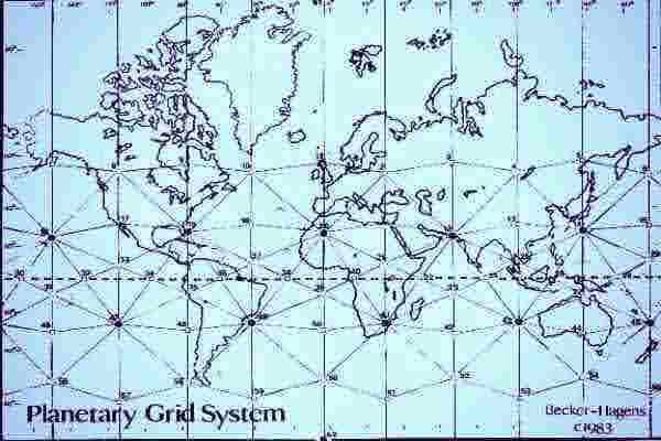
Becker-Hagens Global Ley Lines Grid Map
Becker and Hagens continued Sanderson’s research and identified 26 other similar sites. Here is how they found the pattern. They took the icosahedron pattern and laid it over a map of the Earth. They adjusted the size of the pattern and found it aligned perfectly with many sacred sites. [4]
Researchers such as Sanderson, Becker, and Hagens have increased our insight into these ancient ideas. With this background, let’s explore the specific sites on their map. Some think the Becker-Hagens planetary grid map helps explain why these sites exist. It also shows how they connect to the energy grid lines. Is it only a coincidence that so many sites align with the global ley lines grid map ? Does this data point to cooperation between ancient societies or a global site plan? Some suggest it points to intervention from beyond humanity.
38 Famous Architectural Sites and Structures
It’s important to know that these 38 sites are the only ones located on or near the planetary grid of Becker-Hagens. There are a number of smaller, lesser-known sites that aren’t listed here.
For example, if you visit the Yucatán to see the pyramid at Chichén Itzá (location 34), you’ll find many other interesting sites, including Tulum. Driving south from Cancun’s main airport to Tulum, you’ll see many ancient structures. Most are unnamed and scattered along the roadside. The same goes for if you venture inland to Chichén Itzá. Renting a car is definitely worth it. You miss the crowds at the main sites and find small pyramids and unusual architecture all over the Yucatán.
Learning about them is the first step. Then, we highly recommend you visit as many as you can. You can feel the dynamic energy of these iconic sites for yourself. Create your own famous architectural sites and structures bucket list.
The first five sites run southward down the British Isles.
1. The Standing Stones of Stenness
Many regard this Neolithic monument as the oldest henge in the British Isles, with towering stones 20 feet tall. We know it was laid out in an ellipse with at least 19 stones. Today, only 12 stones remain. This iconic site is near Stromness, Scotland. It’s our first stop on the Becker-Hagens planetary grid map. Enjoy the trip.
2. Solsbury Hill
This site is a flat-topped hill rising about 625 feet, an Iron Age hillfort occupied between 300 BCE and 100 BCE, near Batheaston in Somerset, England.
3. Stonehenge
Stonehenge is one of the most recognizable sacred sites. It is the most visited of the 38 famous architectural sites and structures on the global ley lines grid map. It is the iconic circular set of 30 prehistoric standing stones in Wiltshire, England. The main group of standing stones forms a ring. The central standing stones are 13 feet high, seven feet wide, and weigh around 25 tons each. Experts trace the bluestones used here to a rock quarry in the Preseli Mountains 140 miles away. So, it took a lot of effort and resources to build this site.
4. The Locmariaquer Megaliths
Locmariaquer is a Neolithic-period megalithic structure. Megalithic stones can be solitary or used in groups. Sometimes, they are built on mounds or rocks. Here, they found a way to make the soil solid without using concrete or any binding agents. They remain stable to this day.
The Locmaiaquer in Britain goes by several names. People call it the Er-Grah tumulus passage grave, Table des Marchands, or the Broken Menhir of Er Grah. It is the largest single-stone dolmen erected in the Neolithic period. You can walk through a tunnel from one side to the other. Experts say these structures are older than Stonehenge.
Archaeologists call this type of megalithic structure a dolmen. A dolmen is a stone structure that forms a canopy or roof.
5. The Carnac Stones
Carnac has over 3,000 megalithic standing stones, dolmens, tumuli, and single menhirs. You will find it in Brittany, northwestern France. The most prominent is a section of different sizes, forming rows. There is speculation that these rows or groupings are messages or even codes.
6. The Marhoj Passage Grave
Mårhøj Jættestue, or Mårhøj knoll, is an underground structure or tunnel common in the Neolithic burials of the Danes. This one is in Hindsholm, Denmark.
It is believed to date back to the second century BCE. However, they discovered human bones that were only a few hundred years old at the site in 1868. This indicates that the site was appropriated later for use as a grave site.
This site is located on the upper part of the grid. It goes southeast from the first point at Orkney Scottland. And it shares the same ley line with the first point of Stenness.
Points 7 through 11 on the grid are again going south. This time, they are on the ley line intersecting Turkey and North Africa.
7. The Yazılıkaya Sanctuary
The sanctuary of Hattusa was the capital city of the Hittite Empire. Today, it is in the Çorum province of Turkey. Rock reliefs are a prominent aspect of Hittite art, and those at this site are some of the best examples of this type of art. We have yet to decipher the Hittite language or their graphology.
8. The Great Pyramid of Giza
One of the most famous architectural wonders on the Becker-Hagens planetary grid map is the Pyramids on the Giza Plateau near Cairo, Egypt. It is the oldest of the three pyramids on the site. There is some controversy over who built it. Some say either King Khufu or Cheops. Still, others say it predates both dynasties, and some claim extraterrestrial travelers built it.
It is the last of the original Seven Wonders of the Ancient World. You will note that most of these are within a close radius; these seven famous architectural wonders include:
- The Great Pyramid of Egypt.
- The Hanging Gardens of Babylon are near the Ziggurat of Ur at point 13.
- Statue of Zeus at Olympia (near points 7 in Turkey and 8 in Egypt.
- Temple of Artemis at Ephesus in Turkey, near Olympia, points 7 and 8.
- The Mausoleum at Halicarnassus, Bodrum, Turkey, is near points 7 and 8.
- Colossus of Rhodes (the port of Rhodes, Greece, is close to Olympia at 7 and 8.
- The Lighthouse of Alexandria, Egypt, aligns with points 7 and 8.
This region is an excellent start for your bucket list. It has many famous architectural sites and structures to explore.
9. The Temple Complex of Luxor
The Luxor complex site is on the Nile River in the ancient city of Thebes. Egyptologists estimate its construction to be around 1400 BCE. This complex features several temples on each side of the Nile. It includes four key mortuary temple sites. It includes:
- The Temple of Ramesses II.
- The Temple of Ramesses III at Medinet Habu.
- The Temple of Seti I at Gurna.
- The Temple of Hatshepsut at Deir el-Bahari.
- The two primary temples are Karnak and Luxor.
Unlike the other temples, the Luxor Temple is not dedicated to one god or pharaoh. Instead, it’s about restoring the line of kings. This site is where the pharaohs of Egypt held coronation ceremonies. Luxor is the place where Alexander the Great held his crowning ceremony. Yet, there is no historical reference for him south of Memphis, near modern Cairo.
10. The Valley of the Kings
This Valley of the Gates of the Kings is part of the Luxor complex. It’s a burial site used for 500 years, from the 16th to the 11th century BCE. Here, the pharaohs and nobles of the kingdom are laid to rest in subterranean rock-cut tombs.
Even though it is just a mere 28 miles from the Luxor complex, it deserves to be highlighted on its own. The site contains over 60 individual tombs in an area of 20 square miles. With excavations continuing, more burial sites are being discovered.
11. The Philae Temple
Initially located at the First Cataract of the upper Nile River in Egypt, this temple was a more lavish temple complex. However, since they built the Aswan Dam, this temple has been on an island in the reservoir. Sadly, all outlying structures succumbed to the depths of the artificial Lake Nasser. Bummer. It’s another one of the famous architectural wonders lost to modern development.
The points from 12 to 15, going eastward on the ley line, intersect with point 8 at the Temple of Luxor in Egypt
12. Petra, the Al-Deir Monastery
Petra is one of the seven wonders of the New World. This sacred site on the Earth grid ley lines map is high in the hills of southwestern Jordan. It’s a mixed-use site with religious, military, and burial partitions. The exterior entrance is a beautiful structure carved from solid rock. The building dates to the mid-first century CE. Many say this is a must for your famous architectural wonders bucket list.
13. The Ziggurat (or Great Ziggurat) of Ur
The Ziggurat of Ur is from the Neo-Sumerian era. A Ziggurat is a rectangular-shaped pyramid structure. This one is in the city of Ur near Nasiriyah, which is in the Dhi Qar Province of Iraq. The ziggurat was an essential part of the temple complex shrine to the moon god Nanna. It also served as an administrative center for the city.
14. The Arg-e Bam
Arg-e Bam is an early Persian site dating back to the 4th century BC. Experts say this adobe structure is the largest of its kind in the world. It is an essential link on the Silk Road, dating back prior to the Achaemenid Empire. You can find it in southeastern Iran, in Kerman Province.
15. Mohenjo-Daro
Mohenjo-Daro means “The Mound of the Dead.” It is in the province of Sindh, Pakistan. They built this site around 2500 BCE, and it was one of the most expansive settlements of the ancient Indus Valley civilization. It is one of the world’s earliest major cities, covering about 250 acres.
Points 16, 17, and 18 run southeast on the ley line and join at a major intersection point at Mohenjo-Daro (15).
16. Virupaksha Temple
This ancient temple is part of a group of monuments at Hampi in the Ballari district of Karnataka, India. They dedicate this temple to Lord Virupaksha, a form of Shiva.
17. The Sri Ranganathaswamy Temple
The Sri Ranganathaswamy Temple in Tamil Nadu, India, is the world’s largest functioning Hindu temple. It is dedicated to Ranganatha, the Hindu deity Maha Vishnu.
18. Ramanathaswamy Temple
They dedicate the Ramanathaswamy Temple to Shiva. It’s on Rameswaram Island in Tamil Nadu, India, one of the twelve Jyotirlinga temples in this area. It is only about 240 km south of the Sri Ranganathaswamy Temple.
Point 19 is on a ley line running east/west between points 15 and 20.
19. The Potala Palace
This place is a dzong fortress found mainly in Bhutan and Tibet. These structures have towering exterior walls surrounding an interior with other buildings. This one is in the city of Lhasa, in Tibet. It was once the Dalai Lama’s winter palace from 1649 to 1959. It is now a museum.
The 5th Dalai Lama began construction in 1645. This massive building rises thirteen stories and contains over 1,000 rooms, 10,000 shrines, and about 200,000 statues. It soars 384 ft above Marpo Ri, the “Red Hill.”
The site on which the Potala Palace rises is over an earlier palace of Songtsen Gampo. The current site contains two chapels, which are part of the original building. One is the Phakpa Lhakhang. The other temple is called the Chogyel Drupuk. The latter houses an open cavern identified as Songtsen Gampo’s meditation cave. This cave dates back even further than known historical records.
Points 20, 21, 22 and 24 on a longitude line running north/south through China and Cambodia.
20. The Leshan Giant Buddha
It is the world’s largest stone Buddha statue and the tallest pre-modern-era figure, measuring 71 meters or 233 feet high. The statue is carved out of a cliff face in the southern part of Sichuan Province in China, near Leshan City. It dates to 713 CE and depicts Maitreya (Pali), a Buddha who is to come in the future. A list of the 38 famous architectural sites and structures would not be complete without this site.
21. The Prang Pyramid
Prang is a pyramid with seven tiers in Preah Vihear, Cambodia. This pyramid was created by Jayavarman IV and dates to around 928 CE. It also has a steep staircase on the north side. It is close to the monolithic site at Angkor Wat.
22. Angkor Wat
In Krong Siem Reap, Cambodia, you’ll find Angkor Wat. It is the largest religious monument in the world. It spans 162.6 hectares, which is about 402 acres. It’s one of the most visited famous architectural sites and structures in the world. The site was believed to have been built during the Khmer Empire, which lasted from 802 CE to 1431 CE. Still, many believe it could date back even earlier. The earliest recorded history shows it was a Hindu temple for Vishnu. Then, in the 12th century, it became a Buddhist temple.
Many seasoned global travelers tell us that if you can visit only one spot on the Becker-Hagens planetary grid, this is the one to pick. You can spend weeks exploring this site and see something new every day. This is a definite stop for your historical architectural wonders bucket list.
Point 23 is located on a diagonal axis running northeast/southeast. This intersects with the northern point 15 Mohenjo-Daro. Interestingly, these locations are burial sites.
23. The Tana Toraja tombs
They cut these burial tombs from volcanic boulders. These sites are the focal point for an ethnic group’s culture in a mountainous region of South Sulawesi, Indonesia.
Point 24 is back at the top of the longitude line for points 24, 20, 21, and 22. Not sure why Davies did not simply number all four of these, starting with the northernmost location in China.
24. Imperial Tombs of Xia
These tombs are in Yinchuan, China. The site occupies 30 square miles, including nine imperial mausoleums and 250 graves.
Point 25 is on another ley line projecting from the East China Sea and connecting points 20 and 23.
25. Janggun Chong Pyramid
It’s a tomb for the Korean General Janggun-Chong. It is an impressive structure known as the Pyramid of the East, the burial tomb of former kings.
Janggun Chong is in the ancient city of Gungnae, in Ji’an, Jilin province, China. The pyramid was “rediscovered” in 1905. The pyramid has more than 1,000 stone blocks. The bigger stones are three by five meters. As with many ancient pyramids, we don’t know when they were built or what they were originally for.
Point 26 takes us across the globe to the southeastern Pacific Ocean.
26. Easter Island
Easter Island is where we find the megalithic giant Moai statues. It’s a remote island in the South Pacific Ocean. It sits about 2,300 miles from Chile’s west coast and 2,500 miles east of Tahiti. This island covers 64 square miles. The Dutch explorer Jacob Roggeveen was the first to reach the island in 1722.
Archaeologists believe the statues represent ancient Polynesians. Most of the Moai statues face inland instead of out to sea. There are a few that face out. These are the seven Ahu Akivi. They help travelers find the island. This location is one of the focal “12 vile vortices” noted by Ivan Sanderson in his original research.
It is the most isolated of the points on the Becker-Hagens planetary grid map, but it is worth visiting.
Points 27, 28, and 29 are on a ley line northeast. They are close together on the west coast of South America.
27. Tiahuanacu
Tiahuanaco, or Tiahuanacu, is a pre-Columbian site near Lake Titicaca in western Bolivia. It is a significant archaeological site in South America. It covers around 4 square kilometers. There is a wide variety of historical artifacts here. There are ceramics with unique decorations, monumental structures, and megalithic blocks. They estimate it had a population of 20,000 by 800 CE.
28. La Puerta de Hayu Marca
The “Gate of the Gods” is located high in the Hayu Marca mountain region near Lake Titicaca. Some call it the Puerta de Hayu Marca, Door of Hayu Marca, or Aramu Muru. Local legends talk about people disappearing at this monument. It is an ancient structure predating the Incan civilization. No one knows who built it or what its original purpose was.
29. Machu Picchu
Machu Picchu is another iconic site near Cuzco, Peru. Many historians think it is a 15th-century Inca structure. There must have been valid reasons to construct it high on this mountain ridge. Was it built on this site for protection or some other reason? It covers 2,400 meters on a mountain just under one mile high. The Urubamba River flows nearby, which creates a unique tropical mountain climate.
Points 30 and 31 are on a ley line that runs northeast through the peninsula between North and South America. These sites are only about 185 km apart.
30. Tazumal Pyramid and Temple Complex
The Tazumal complex is a pre-Columbian Mayan site in Chalchuapa, El Salvador. It’s a complex within the larger area of the ancient Mesoamerican city of Chalchuapa in western El Salvador.
31. Copán Ruinas
Copán is an ancient Maya city in Honduras, close to Guatemala. It was the capital city in the Classic period from the 5th to the 9th centuries CE. But its history goes back much further. Excavations reveal that people lived there for over two thousand years. It spans from the Early Pre-Classic period to the Post-Classic period. The city has distinctive sculptures that follow the tradition of the lowland Maya.
Points 32 through 34 run northeast along one of the ley lines that cut across the Yucatan Peninsula.
32. Pyramid of the Sun
“The Pyramid of the Sun” is part of a large complex in the middle of Teotihuacan, Mexico. It’s the largest building in Mesoamerica, constructed around 200 AD. The structure is 220 meters (720 feet) high and 224 meters (740 feet) wide.
33. The Tikal Temple Complex
Tikal is an ancient Mayan city. Hieroglyphics at the site call the city Yax Mutal or Yax Mutul, which means “First Mutal.”
Tikal is in the Guatemalan rainforest, Selva Lacandona. It is one of the most significant archaeological sites of the pre-Columbian Maya civilization. There are more than 30 magnificent pyramids and building structures in this complex.
34. El Castillo de Chichén Itzá
El Castillo is Spanish for “the castle.” It is a step pyramid in Mexico on the Yucatán Peninsula. This pyramid is at the center of the Chichén Itzá archaeological site. The Maya name “Chichén Itzá” means “At the mouth of the well of the Itza.” It is also called the Temple of Kukulcán.
Points 35 through 38 are in the United States.
35. Crystal River Mound Complex
The Crystal River Mound Complex is a historic Native American site. Evidence shows it was a multi-use site that was in use for 1,600 years. It covers over 60 acres and contains several temples with burial mounds in Crystal, Florida.
36. The Emerald Mound
The Emerald Mound near Stanton, Mississippi, is the second largest of its kind in the United States. It has a unique pentagram-like shape.
Excavations show it was built over an extended period from 1200 to perhaps 1700 CE by the Plaquemine Native American Indians. It was likely a structure made for worship. There is evidence of eight ceremonial stone structures at the top. The mound rises 65 feet above the surrounding ground.
Although it is an exciting site, we wonder why it is listed on the global ley lines grid map. It does not align with the diagonal going from Crystal River, Florida, to Collinsville, Illinois. This location is too far west to align with the pattern of the Earth grid ley lines map. However, this site may be on a minor ley line.
There are other, more significant sites and structures on this ley line from Florida to Illinois. One of these is the Track Rock Gap Archaeological Area. It is in the Brasstown Ranger District of the Chattahoochee National Forest in Georgia. This area is known for petroglyphs or marked stones. The Track Rock site has six table-sized soapstone boulders. Each of these contains hundreds of symbols carved or pecked into its surface. Archaeologists have speculated dates for the Archaic Period, 8,000 to 1,000 BCE. We still need to decipher these petroglyphs.
37. Monks Mound
It is the largest pyramid in northern Mesoamerica, which dates back to 900–955 CE. This mound is in the Cahokia Mounds near Collinsville, Illinois.
This mound is about 100 feet high and 955 feet long, including an access ramp 775 feet wide. It makes “Monks Mound” the same size at its base as the Great Pyramid of Giza, at 13.1 acres. Its base’s perimeter is larger than the Pyramid of the Sun at Teotihuacan. This structure is a platform mound. Excavations show it supported some kind of wooden structure on the summit. This platform mound is made by compacting soil, sand, and clay layers. It is a different building technique from that of other cultures, using enormous stone blocks.
38. The Grave Creek Mound
Grave Creek is a Native American burial mound in West Virginia. It is a large cone-shaped burial mound measuring 62 feet high and 240 feet in diameter. The builders of this site moved more than 60,000 tons of material to create it in 250–150 BC.
Final Thoughts on the List of Famous Architectural Wonders
Even if you consider ley lines pseudoscience, you cannot deny the precise alignment of these sites. Their pattern defies coincidence or chance. People picked these sites to build significant structures. We know they located them on these lines for some purpose that is lost in antiquity.
Many of these sites, which were erected in the last two millennia, are believed to be additions to earlier structures. Perhaps those who adopted the sites didn’t know why the ancients chose them. We do know they understood these sites are aligned with astronomical occurrences. They just regarded them as unique. How did the ancient builders choose these sites? Why did they align many sites with annual celestial sun and moon phases?
What knowledge did these ancient builders possess? We know for sure that many of these sites align with the icosahedron. This pattern is part of the folklore and mystery that is yet to be deciphered.
References
- Nikola Tesla. Wikipedia.
- Why Nikola Tesla was obsessed with the Egyptian pyramids, Big Think
- Ivan Sanderson. Wikipedia.
- The Science and History of Ley Lines: A Comprehensive Map Guide. Simpli
- Simon E. Davies is the source of the planetary grid photo
*Wikipedia is an excellent resource for investigating all the sites listed.