The vortex energy points map shows how many ancient structures are a part of a global network. Did they possess knowledge of energy amplification through ley lines? We are only just beginning to understand the importance of these locations and this energy.
Many ancient cultures built mysterious structures in places with earth energy lines. We don’t know how they found these sites. All we know is they spent considerable resources to construct at these locations aligning with earth energies.
Many of the sacred sites are remote or challenging to navigate the terrain. So, they must have had some compelling reasons to build on them. We will explore twelve sites that share intriguing similarities.
Becker Hagens Ley Lines Energy Vortexes
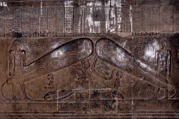
Ancient legends discuss how people could tap into the Earth’s energy at specific points. We know little more than that. We don’t know how they discovered these sites or how they used the energy. There are hints about how this energy may have been used in Egyptian hieroglyphs. The Dendera light is a hieroglyph at the Hathor temple, which shows two long cylinders with wavy lines inside. Some believe this indicates the use of energy amplification through ley lines.
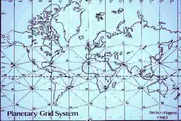
William Becker and Bethe Hagens placed Icosahedron on a map of the world. When they did, they found it linked to many sacred sites. They called this network the Unified Vector Geometry 120 Polyhedron or Earth Star. The pattern shows how sacred geometry vibrational energy is etched on the globe as ley lines energy vortexes.
Later, a cryptozoology founder, Ivan T. Sanderson (1911-1973) (1), discovered a common link between many sites worldwide. He identified 12 major points he called vortices. We doubt these ancient cultures had contact with one another. A pattern emerges, giving clues or potential reasons they choose these locations.
This map shows many well-known archeological sites and areas of unexplained phenomena. The Becker Hagens ley lines map (2) shows the pattern that aligns them. We’ll focus our attention on twelve of these well-known sites.
The 12 Vile Vortices Map
Vortices are spiraling or swirling masses of energy. Hurricanes, tornadoes, and whirlpools are examples of natural occurrences of this energy. Electromagnetic fields can also behave in this manner. It can be observed in the swirling movement of the Northern Lights. It is not surprising that these types of phenomena occur in specific areas or zones.
Mr. Sanderson points to twelve sites with strange and unusual activity. He calls them Vile Vortices. These sites are known for unusual electrical and magnetic activity that causes problems for travelers. An unusual number of marine and aircraft disappearances occur in these areas. Sailors and pilots report instruments that fail and go crazy. So, today, travelers still avoid these areas if possible. We have yet to find a way to predict when these energies will surge and create dangerous conditions.
Saga magazine published Sanderson’s 12 vile vortices map in 1972. It appeared in the article, The Twelve Devil’s Graveyards Around the World. This article shows places with earth energy lines that are known for mysterious, unexplained activity. They are known as locations where ships and planes have disappeared. The world vortex energy points map shows how these sites correspond to a complex geometric pattern.
Science is defined in the dictionaries as the pursuit of the unknown, yet science today is coming more and more to insist that it not be bothered with this, and it has reached a point where anything that is not already known is frowned upon.” — Ivan T. Sanderson
Places with Earth Energy Lines
1. The Bermuda Triangle
The Bermuda Triangle is an area in the North Atlantic Ocean, forming a triangle between Florida, Bermuda, and Puerto Rico. This area is known for the disappearance of ships and planes and the sighting of unidentified flying objects. Some point to this site as an example of energy amplification through ley lines. Either someone knows how to use this energy, or this energy is simply leaking out in uncontrolled ways.
2. Easter Island
Easter Island is a small island in the South Pacific Ocean. It is famous for its statues of giant alien-looking faces, the Moai. Easter Island is remote, some 2,300 miles from the west coast of Chile and 2,500 miles east of Tahiti.
The first recorded contact was made in 1722 by the Dutch explorer Jacob Roggeveen. Some believe the statues are alien faces, while others say they are stylized versions of Polynesian people who inhabited the area. Most statues face inland instead of out to sea to greet travelers. The exception is the seven Ahu Akivi, which face outward toward the ocean, perhaps to greet or scare away travelers.
3. The North Pole
The most inhospitable climates on the planet are the poles. These points are the magnetic anchors for the Earth. The geographic North and South Poles mark the opposite ends of a central axis on which the world turns. These points are the focal points for magnetic energy.
The Northern or Polar lights (Aurora Polaris) are natural phenomena in the northern and southern hemispheres. They are a visible display of magnetic energy.
4. The South Pole
Expeditions to the north and south poles are dangerous ventures. Extreme temperatures and unpredictable weather cause vile vortices, which have claimed many lives.
5. Karachi
Karachi is located on the southern coast of Pakistan along a natural harbor of the Arabian Sea. It is near the ancient city of Mohenjo-Daro, one of the earliest major urban settlements. There is a theory that suggests unusually high radiation levels in the area could be evidence of ancient nuclear weapons used at this site.
6. Hamakua
This site is a region on the northeast coast of Hawaii. It is the site where there was once a high-energy volcano.
7. The Devil’s Sea
The Devil’s Sea is south of Tokyo. This area is known for the disappearance of ships and airplanes.
8. The Wharton Basin
This basin is an area on Earth with great ocean depths and is yet to be explored. It is the marine basin area of the northeast quarter of the Indian Ocean. This basin bears the name of William Wharton (1843-1905), one of the first to discover it. It is also known as the Cocos Basin, after Cocos Island. Some call it the West Australian Basin because it lies east of the Ninety-East Ridge and west of Western Australia.
9. New Hebrides Trench
One of the deepest locations underwater is the Hebrides Trench. It is between Vanuatu and New Caledonia’s islands. Its deepest point is over 25,000 feet (7,600 meters). Who knows what’s down there?
10. The Megalithic Ruins of Algeria
These ruins are located just south of Timbuktu. Most of these structures are unexplored, but some are so unstable that we cannot explore them.
11. The South Atlantic Anomaly
According to researchers, the Van Allen radiation belt dips exceptionally close to the Earth’s surface. Geomagnetic activity is directly related to this phenomenon. There is a small chain of underwater volcanoes near Angola and St. Helena, where this activity is centered.
12. The Megaliths of Zimbabwe
Home to supermassive stone structures. This site is about 19 miles (30 km) southeast of Masvingo (formerly Fort Victoria). The ruins’ central area is about 200 acres (80 hectares). It makes Great Zimbabwe the largest of 150 stone ruins spread across Zimbabwe and Mozambique. Sanderson believed that hot and cold airflows cause electromagnetic disturbances. So, the magnetic energy may cause abnormal activity in certain areas.
“we are speaking about an intelligent geometric pattern into which, theoretically, the Earth and its energies are organized—and possibly in which the ubiquitous megalithic sites are also positioned.” — David Hatcher Childress
The World Vortex Energy Points Map
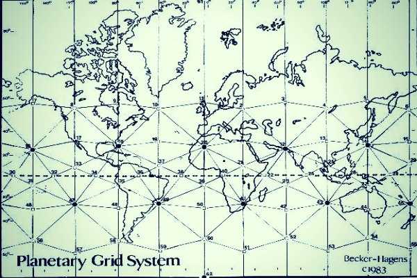
Scientists Alexander Goncharov (3), Evgeny Morozov (4), and Mikhail Makarov (5) made an interesting assessment. They saw how to flip the Icosahedron (6) inside out into the dodecahedron (7). Then, you can plot these extra points on the grid. These align with the original 12 points of the Icosahedron on the grid. The result is a worldwide grid that plots several significant monolithic structures and sacred sites. Again, this cannot be a coincidence.
It is obvious that many ancient cultures could identify these places with earth energy lines. This grid contains over 4000 sites of historical and spiritual significance. Famous sites include the Great Pyramid, Stonehenge, the stone heads at Easter Island, and Mexico’s sun and moon pyramids. It also links ancient mystical sites, churches, temples, henges, and burial sites. They are all built on aligning with the earth energies on this network.
The Irish referred to these energy networks as fairy paths, while the Germans named them holy lines. The Greeks called them the sacred roads of Hermes, and the Chinese termed them dragon currents.
Many other cultures claim they could even see these lines and build roads and buildings accordingly. Even Plato spoke of this in his work, Timaeus. He explained the places with earth energy lines as the synthesis of the platonic solids. Somehow, this pattern expresses the ideal body of the cosmos.
These ancient cultures possessed knowledge of the vortex energy points map we lost. The rise of anti-intellectualism and organized religion continues to stunt scientific exploration. We are only now rediscovering parts of this knowledge. However, we have more questions than answers. Some believe this energy source is what Nikola Tesla (8) investigated. He thought the magnetic field of the Earth was a free source of energy, but his research was undermined and discredited by Thomas Edison. Mr. Edison wanted to develop a way to generate and sell electricity.
Sacred Geometry Vibrational Energy
Mathematics and geometry are subjects that intrigue many people. Geometry, in particular, is interesting because we can see it in action when we put sand on a flat surface. We vibrate the surface, and a shape appears in the sand. As we change the frequency of the vibration, different geometric shapes appear.
We see how certain frequencies cause vibrations that form specific geometric patterns. These patterns are part of a larger scheme and lead to sacred geometry theory (9). Sacred geometry is the idea that geometric shapes are the infrastructure for the universe.
The Becker-Hagans grid shows how sacred geometry governs the structure of the physical universe. Sacred geometry vibrational energy ascribes symbolic meaning to geometric shapes and proportions.
We can identify these patterns in nature. For instance, the hexagon is the structure of beehives and the dragonfly’s eyes. We find this design on many turtles. The spiral is another typical geometric pattern, with hurricanes, pinecones, and the Nautilus shell. The beehive is an example of how this structure can connect living things.
Ley lines and sacred geometry vibrational energy are the patterns of life. For example, the Nautilus shell’s logarithmic spiral enables it to grow without changing shape. Similarly, honeybees construct hexagonal cells to hold honey. It is a perfect structural shape that can endure impacts and harsh temperatures. Ancient cultures ascribed meanings to these patterns for reasons that escape modern man. A mainstream BBC news article (10) discusses the mysterious nature of these energy ley lines and the planetary grid.
Energy Amplification Through Ley Lines
Have you ever visited a place that instantly gave you a surge of positive energy? Perhaps you didn’t know it then, but that location might have intersected one of these invisible pathways of planetary energy. There are thousands of these intersecting lines on the Earth, so the likelihood that you have encountered one is high.
Aligning with Earth Energies
Learning about these vibrational connections helps us understand our relationship to the planet. You probably have felt a connection to certain places. You may have felt certain areas seem to emit positive or negative energy. If you live near one of the key energy lines, you may have become accustomed to the energy flow. Some people are sensitive to this energy, and they can draw upon it for creative or healing power.
Even if you don’t live near one of these energy conduits, you can still connect with it. For example, many practitioners of distance healing practices, like Reiki, are available. Several processes facilitate healing and spiritual exploration.
It is not uncommon for many Shamanic healers to trace their lineage to regions along these ley lines. Many use energy collection as an integral component of their routine health and wellness strategy.
Transfer the concept of Ley Lines and vibrational geometry to the human body. Now, you have the network of alignment used in Eastern thought and medicine. The primary network is the energy centers down the spine, known as chakras.
Final Thoughts
The vortex energy points map is only the beginning. We can see how many ancient sites were built on this grid. It’s important to find out how they found the energy and what they used it for.
These mysterious places with earth energy lines might be another answer to the energy crisis and climate change. Perhaps science will be able to rediscover the key to energy amplification through ley lines. Aligning with Earth energies could be a way to curb fossil fuel use.
References
(1) Ivan T. Sanderson, Wikipedia
(2) Becker-Hagens planetary grid, Vortex Hunters
(3) Alexander Goncharov, Wikipedia
(4) Evgeny Morozov, Wikipedia
(5) Mikhail Makarov, Wikipedia
(6) Icosahedron, Wikipedia
(7) Dodecahedron, Wikipedia
(8) Nikola Tesla, Wikipedia
(9) Sacred Geometry, Wikipedia
(10) BBC News Article on Ley Lines